
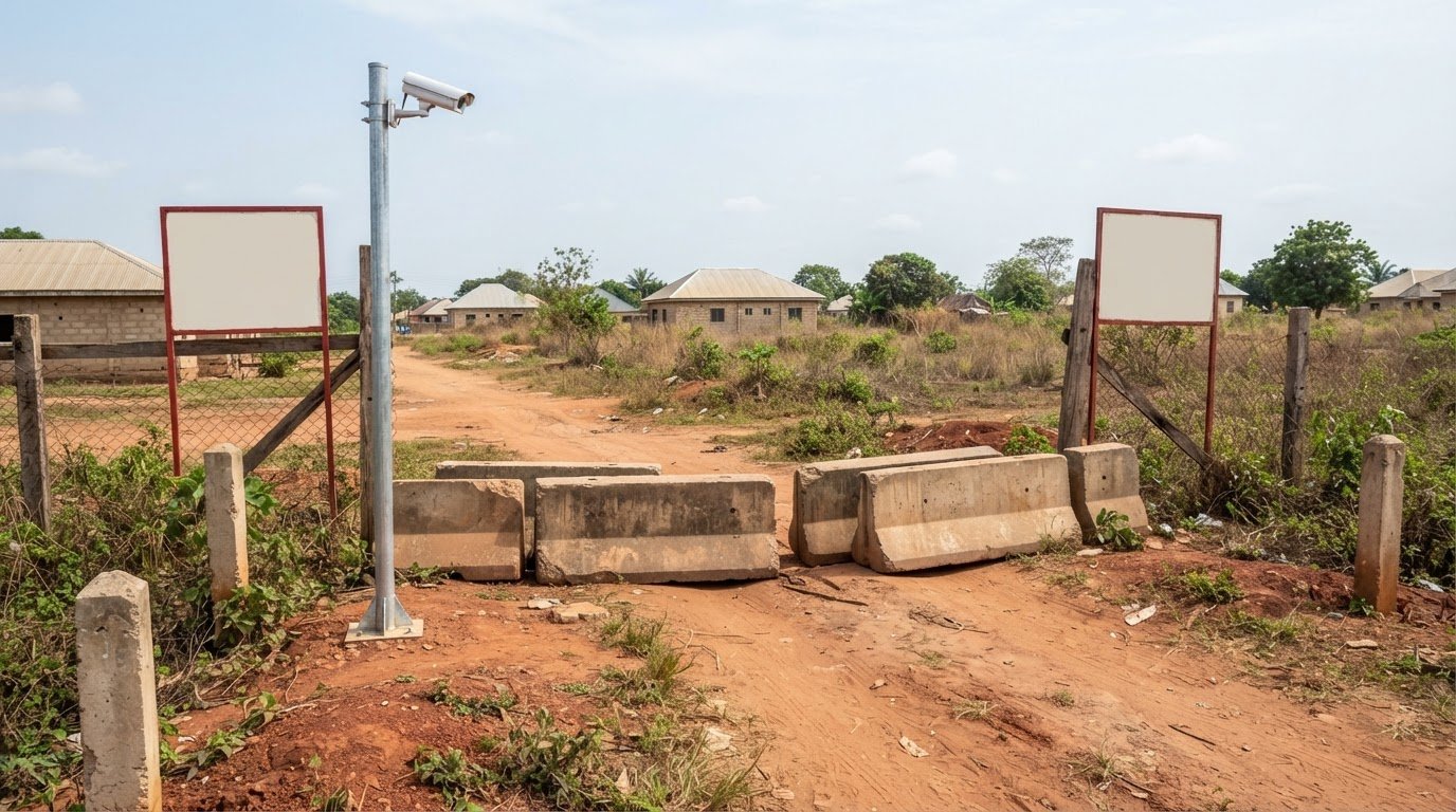
A sign alone won’t secure vacant land. A practical approach to how to secure your vacant land from trespassers combines boundary signs, barriers at vehicle access points, CCTV monitoring, and regular boundary checks. Together, these measures can discourage unauthorised access and help document activity on the property.
It’s understandable to want a dependable way to protect land that isn’t occupied every day. Visible signs communicate that access is restricted, while physical barriers can make casual vehicle entry more difficult. Monitoring and regular boundary checks add oversight, making potential access issues less likely to go unnoticed.
This guide explains how these measures work in Nigeria, what each can and can’t do, and how to coordinate them as part of a land-management plan. You’ll also learn how to choose a combination suited to your site, considering its boundaries, access routes, and need for recorded evidence. No single measure addresses every risk, but a considered approach can make vacant land easier to oversee and help you respond when concerns arise.
Key Takeaways
- Well-positioned boundary signs make restricted access clear and help reinforce the land’s limits.
- Concrete blocks at vehicle entry points can help prevent cars from driving onto an unoccupied site.
- CCTV can document activity and provide footage that may support an investigation.
- Regular boundary checks help reveal vulnerable access areas so security measures can be focused where they matter most.
1. How professionals post no-trespassing signs along property boundaries
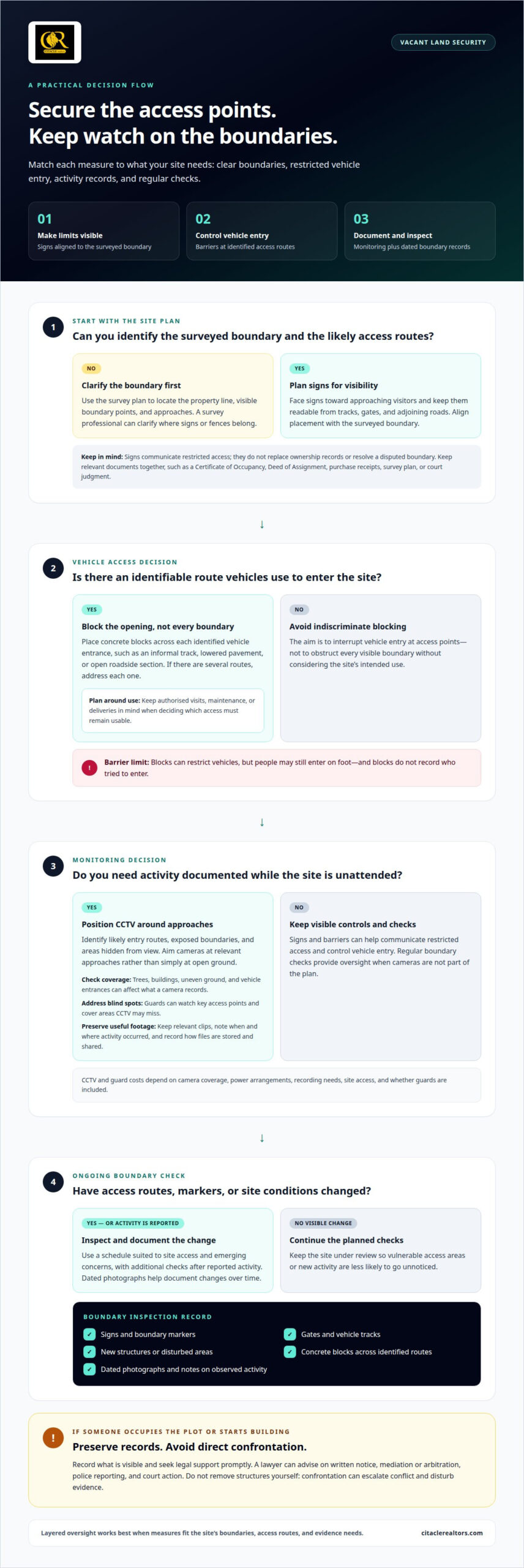
Professionals begin by locating the property line using the survey plan, then identify visible boundary points and access routes. Signs should face approaching visitors and remain readable from tracks, gates, and adjoining roads. One landowner placed signs every 50 yards along a hunting property’s boundaries; that example isn’t a universal spacing rule.
To mark and fence vacant land responsibly in Nigeria, align the work with the surveyed boundary and avoid extending structures onto neighbouring plots. A survey professional can use the survey plan to clarify where signs and fences belong. The Food and Agriculture Organization of the United Nations (FAO) explains that a land parcel reference number can connect a plot with survey information and ownership records.
Ownership documents may include a Certificate of Occupancy, Deed of Assignment, purchase receipts, survey plan, or court judgment. A parcel reference number can also help identify the plot and connect it with relevant records. Keep these documents together so it’s easier to establish which land the signs are intended to protect.
There’s no single fencing cost for every Nigerian plot. A professional quote depends on boundary length, terrain, access, materials, and fence design.
Without a permanent fence, professionals can arrange visible signs, concrete blocks at vehicle entrances, and CCTV monitoring. Boundary checks help identify disturbed markers or new access tracks.
The legal consequences of prolonged occupation can depend on the circumstances, so seek legal advice promptly if someone occupies the plot. Signs communicate restricted access, but they don’t replace ownership records or resolve a disputed boundary.
If someone occupies the plot or starts building, preserve records and seek legal support promptly. A lawyer can advise on written notice, mediation or arbitration, police reporting, and court action. A possession order may be enforced through bailiffs.
Confronting trespassers or removing structures yourself can escalate conflict and disturb evidence. Avoid direct confrontation, record what’s visible, and seek legal guidance.
A professional should inspect on a schedule suited to site access and emerging concerns, with additional checks after reported activity. The checklist should cover signs, boundary markers, gates, vehicle tracks, new structures, and dated photographs. Those records help document changes over time.
2. How professionals block vehicle access with concrete blocks
Start by identifying the routes vehicles use to enter the site. These may include an informal track, a lowered pavement, or an open section beside a road. Concrete blocks across those access points can prevent vehicles from driving onto the land. The goal is to interrupt vehicle entry, not to obstruct every visible boundary indiscriminately.
Begin placement with a site assessment. Identify the approach route, check how vehicles reach it, and choose positions that close the opening. A row of blocks across a track, for example, can prevent vehicles from driving directly onto the plot. If the site has several entrances, address each one. Blocking one route while leaving another open may simply redirect access.
Consider access requirements too. You may need a route for authorised visits, maintenance, or deliveries. In that case, distinguish the blocked vehicle entrance from any access that must remain usable. Plan barrier placement around the site’s intended use instead of placing blocks without considering how the property will be managed.
Concrete blocks restrict vehicle access, but they don’t secure every part of a vacant site. People may still enter on foot, and blocks don’t record who tried to enter. Signs can communicate that access is restricted, while CCTV can document activity. Combining these measures gives you a clearer picture of site access and activity.
After placement, a professional can include the barriers in routine boundary checks. The inspection can record whether blocks remain across each identified route, whether vehicle tracks appear elsewhere, and whether authorised access remains practical. Dated photographs make changes easier to document. For coordinated land access planning, consider how entry control fits the property’s wider management needs.
3. Professional CCTV monitoring and evidence collection
CCTV can monitor an unoccupied site 24/7, helping document activity when no one is present. In many high-end markets, property managers leverage automated surveillance to track perimeter risks; for example, firms specializing in AI security camera installation Beverly Hills illustrate how intelligent video monitoring and access-control systems can protect vulnerable premises. A professional first identifies likely entry routes, exposed boundaries, and areas hidden from view. Cameras can then be positioned to capture relevant approaches rather than simply pointing toward open ground.
Account for practical site conditions when planning coverage. Trees, buildings, uneven ground, and vehicle entrances can affect what a camera records. Security guards can watch key access points, such as gates, and cover areas within CCTV blind spots. This adds an on-site presence where camera footage alone may leave gaps.
In Nigeria, CCTV monitoring or guards can help oversee vacant property. Costs depend on camera coverage, power arrangements, recording needs, site access, and whether guards are included. These factors shape the setup and ongoing monitoring requirements.
Footage from an unoccupied site can support investigations and prosecution. To make recordings useful, the professional managing the system should preserve relevant clips, note when and where activity occurred, and keep a clear record of how files are stored and shared. For example, footage showing a vehicle entering through a particular gate can be considered alongside dated inspection photographs and incident notes.
Neighbours and community leaders can help by reporting unusual activity near the property and noting when access appears to have changed. Set up a clear contact arrangement so reports reach you or your property representative promptly. Ask them to observe and report, not confront suspected trespassers.
During a site review, check camera views, recording continuity, visible damage, and blind spots. Consider whether vegetation or new structures obstruct the view. These checks help keep monitoring aligned with changing site conditions, while dated footage and written incident records create a clearer account of access.
4. How professionals identify and flag vulnerable boundary areas
A boundary review starts with the survey plan and a walk around the plot. Follow each boundary, noting damaged markers, open approaches, worn tracks, and places where vegetation hides the line. For example, record and follow up on a corner marker that’s hidden from the adjoining stretch. This assessment helps determine how to secure your vacant land from trespassers by identifying its actual weak points.
Access patterns show where attention is needed. A professional records vehicle tracks, footpaths, gaps beside existing barriers, and signs of recent disturbance. CCTV coverage can reveal blind spots near boundary corners or entrances. These observations help distinguish an exposed approach from a boundary that remains visible and easier to monitor.
Record findings against a site plan rather than relying on verbal notes. Mark each vulnerable location, describe the observed issue, and add dated photographs taken from a consistent viewpoint. For example, compare a photograph of a displaced marker with the survey plan during a later review. Clear records help track changes without treating an observation as proof of a boundary dispute.
- Obstructed line: Note vegetation or stored materials that hide markers.
- Open access: Record gaps, tracks, or entrances where people or vehicles can approach.
- Monitoring blind spot: Flag a location outside the view of installed CCTV.
- Possible disturbance: Document moved markers, fresh tracks, or new structures.
Use flags to make observations easy to locate during follow-up, while respecting adjoining land and avoiding changes to disputed markers. If the survey plan and visible features appear inconsistent, record the discrepancy for appropriate review instead of moving a marker. This helps guide decisions about how to secure your vacant land from trespassers without creating confusion about the property line.
For a coordinated review of vulnerable areas and ongoing site oversight, arrange professional property management suited to the land’s access and boundary conditions.
Citacle Realtors: Residential Land Sales
Citacle Realtors offers residential land sales for people considering a plot for future ownership or development. Clear boundaries and practical access arrangements are important when planning how to oversee a vacant property after purchase.
If you already own land, Citacle Realtors’ Property Management service is a relevant next step when you need professional oversight. It can suit owners seeking a coordinated approach to monitoring property condition and recording access concerns. Facilities Management may also be relevant when the property needs attention to its facilities.
Choose support that matches your situation: land acquisition, ongoing property oversight, or facilities coordination. These services complement the security measures discussed in this guide, but don’t replace legal advice where ownership or occupation is disputed.
Please contact Citacle Realtors to discuss your land or property needs.
Plan for the land’s next chapter
A plan for how to secure your vacant land from trespassers should reflect what you want the property to become. A plot awaiting development may need a different approach to access and oversight from land held for future investment. As your plans change, review how the site is accessed and monitored so its management remains aligned with its intended use.
Ownership decisions and ongoing oversight are closely connected. If you’re considering a land purchase or need support managing property, contact Citacle Realtors to explore a next step suited to your goals. Discussing your plans can help you move forward with a clearer view of the property’s needs.
Contact Citacle Realtors to discuss your property needs. A thoughtful next step can help you approach your land plans with confidence.
Frequently Asked Questions
What are the most effective ways to deter trespassers from vacant land?
The strongest approach combines visible access warnings, physical controls at vehicle entrances, and a way to notice or document unauthorised activity. Match the measures to the plot: land beside a frequently used road may need clearer entry control, while a remote parcel may benefit from a defined monitoring and reporting arrangement. Assign someone to receive incident reports so concerns are acted on promptly.